Continents, Oceans, Extinction
How One Sequence of Catastrophes Reshaped the Earth

A Note on Dates: Conventional dates (Ma = millions of years ago) are used as signposts for sequence, not as endorsement of their accuracy. The order of events matters more than the length of the “waiting room” between them.
The Claim
The Earth has grown. The continents were once joined together on a smaller planet. The ocean basins are cracks that opened as the Earth’s radius increased — not gaps left by drifting continents on a fixed-size globe. Each catastrophic pulse of expansion cracked the crust, released continent-scale volcanism, devastated the biosphere, and left the seafloor as a record of the rupture.
This is not gradual drift. This is pulsed expansion — violent episodes separated by periods of relative stability. The evidence is in the fossils that cross ocean barriers, the seafloor ages that mark each pulse, and the mass extinctions that coincide with each major rupture.
Two Ways to Read the Evidence
The observations are not in dispute. Fossils of identical species appear on continents now separated by oceans. Large Igneous Provinces correlate precisely with mass extinctions. The ocean floor has a maximum age of about 200 million years. The continents fit together on a smaller globe. What is in dispute is the interpretation.
| Plate Tectonics (Mainstream) | Expansion Tectonics (Alternative) |
|------------------------------|-----------------------------------|
| Earth radius is constant | Earth radius has increased |
| Continents drift apart | Continents are pushed apart by growth |
| Oceans are gaps between drifted continents | Oceans are cracks that opened in the crust |
| Old crust “subducts” into mantle | Crust expands |
| Change is gradual, uniform | Change is catastrophic, pulsed |
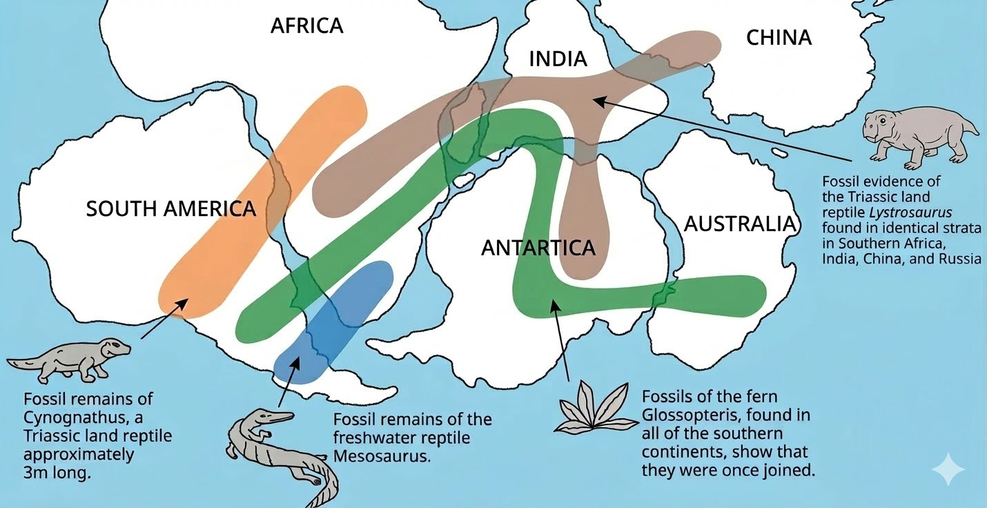
Evidence One: Continents Were Joined
Before the oceans existed, the continents formed a continuous shell. The fossil record provides irrefutable proof: identical species appear on continents now separated by thousands of kilometers of ocean — species that could not have crossed saltwater.
Glossopteris — a fern with seeds too heavy for wind or ocean dispersal — appears on all southern continents. Mesosaurus — a freshwater reptile that could not survive in salt water — is found in both South America and Africa. Lystrosaurus — a land-dwelling reptile — appears in Africa, India, and Antarctica. These distributions are impossible unless the continents were once connected by land, with no ocean barriers between them.
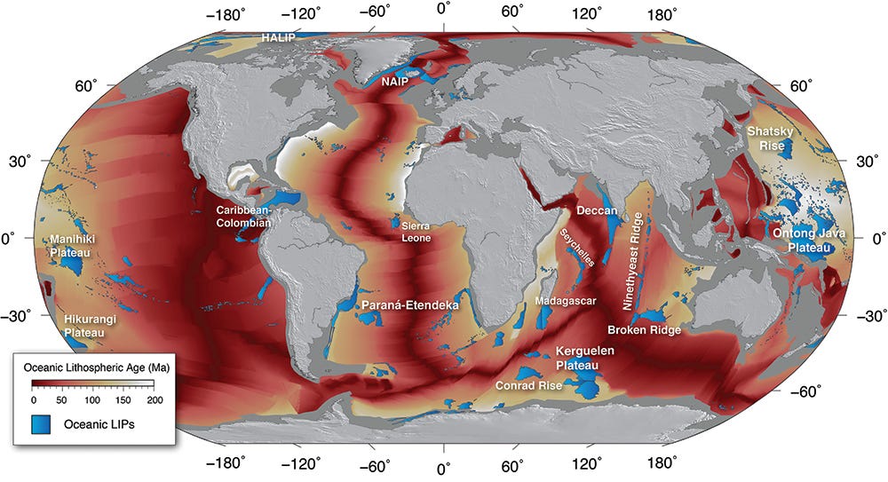
Evidence Two: The Seafloor Record
If continents drifted on a fixed-size Earth, we should find oceanic crust of all ages. But we don’t. Oceanic crust has a maximum age of approximately 180-200 million years. In the expansion model, this is not coincidence — it is because the ocean basins did not exist before the first expansion pulse. The seafloor preserves the record of ruptures that opened the gaps between continents.
Evidence Three: The Pulse-Extinction Correlation
The most striking pattern in the geological record is the correlation between Large Igneous Provinces and mass extinctions. Massive volcanic outpourings coincide precisely with the worst extinction events in Earth’s history. In the expansion model, these are not random coincidences — each LIP marks where the crust cracked during an expansion pulse, releasing magma on a continental scale and triggering biosphere collapse.
| Pulse Name | Signpost Date | LIP Signature | Extinction |
|------------|---------------|---------------|------------|
| The Siberian Pulse | ~252 Ma | Siberian Traps (7M km²) | End-Permian (96% species) |
| The Atlantic Pulse | ~201 Ma | CAMP (11M km²) | End-Triassic (~75%) |
| The Deccan Pulse | ~66 Ma | Deccan Traps (500K km²) | End-Cretaceous (~75%) |
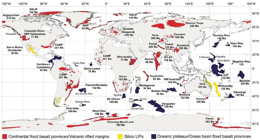
Oceanic LIPs: The Submarine Record
The map above shows oceanic LIPs — massive volcanic formations on the seafloor. These record additional pulses in the expansion sequence, preserved underwater. Arranged chronologically, they show the progression of crustal rupture:
| Oceanic LIP | Signpost Date | Location |
|-------------|---------------|----------|
| Shatsky Rise | ~145-150 Ma | Northwest Pacific |
| Paraná-Etendeka | ~132-134 Ma | South America / Africa |
| Ontong Java Plateau | ~120-125 Ma | Western Pacific |
| Kerguelen Plateau | ~110-130 Ma | Southern Indian Ocean |
| Caribbean-Colombian | ~90-95 Ma | Caribbean region |
| Ninetyeast Ridge | ~40-80 Ma | Indian Ocean |
| NAIP (North Atlantic) | ~55-60 Ma | North Atlantic |
The Thermal Blink: Forensic Evidence
If these volcanic episodes lasted millions of years, we should see evidence of time between the lava flows: soil formation, river channels, weathered surfaces. But the rock record shows something different.
The lava flows are cleanly stacked — one upon another with sharp, parallel boundaries. Contact surfaces are often glassy and unworn. There is no soil development between successive flows. No river channels cutting across. No weathered surfaces. The layers lie flat and conformable, as if each was deposited before the previous one had time to cool.
This is exactly what the expansion model predicts: a Thermal Blink — rapid deposition in which each pulse of volcanism completed before significant erosion could begin. The absence of weathering becomes positive evidence for catastrophic timing. We can point to specific outcrops and ask: where are the soils? Where is the evidence of the millions of years supposedly separating these flows? The silence of the rock record speaks.
What It Means
The Earth grew. The continents were torn apart. Oceans filled the gaps. The dinosaurs — and most other species — did not gradually decline. They were eliminated in catastrophic pulses that cracked the planet’s crust and collapsed the biosphere.
This is not speculation. The evidence is in the fossils that prove continents were joined, the seafloor ages that record each rupture, and the precise correlation between LIPs and extinctions. What changes is not the observations, but the story we tell about them.
Key Sources
Wignall, P.B. (2001). “Large igneous provinces and mass extinctions.” Earth-Science Reviews.
Maxlow, J. Expansion Tectonics. jamesmaxlow.com — Small Earth modeling with 99% crustal fit accuracy.